Tuesday, April 30, 2013

Sandia Peak - via the Turquoise Trail

Yesterday morning after baking some peanut butter muffins, I grabbed a couple of them and a cup of orange juice, packed a couple mesquite turkey breast and provolone cheese sandwiches then, headed east on I-40 where I caught the Turquoise Trail (highway 14) north towards Santa Fe.  I decided not to use the Tramway as originally thought and opted for seeing more of the mountain and countryside around it -- spent the $17 on gas instead of the Tramway.

I only went a short distance north on highway 14 and then cut over on highway 536 at Sandia Park where I headed for Sandia Crest (elevation 10,678 ft.) and hoped to enjoy my breakfast at the top.  This "Scenic Byway" (as it was described on the highway signs) was a two-lane, winding road with minimal pullouts for taking in the scenic views and whenever you did pullout you didn't have the views for pictures unless you parked and hiked to some unknown spots (no good trail maps were posted either -- just signs that you had better have a "recreation pass" on your car or get ticketed).

It wasn't any different at the top too and neither the gift shop nor bathrooms were open for use or "recreation" -- lots more signs indicating you had better pay the $3 (pay stations were open, of course).  The view at the top was fairly spectacular but, the wayfinding signage had been vandalized with big black markers so, they were fairly illegible (except for one out of the four).  Thanks a lot you sick little bastards (whoever you are).

After taking some pictures, this old man had to head back down the road to the nearest open facilities where I enjoyed one of those muffins and the cup of orange juice with a banana.  I then drove up and down the road some short distances and pulled out on some dirt shoulders to get some more picturesque views to the east and the valley below where the Turquoise Trail wound its way north past vineyards and in front of the San Pedro Mountains and the Ortiz Mountains -- beyond that, nothing but, the featureless desert I had seen last spring on my trip north from Carlsbad and through Roswell (on my way to southwest Colorado).

From there I headed to a nearby entrance to an unimproved road (route 165) which is usually closed from Nov. 1st to May 1st -- it was open so I took the 4-wheel road some 6 or 6.5 miles along the mountainside and along a small creek before hitting an asphalt highway again on the other side of the mountain.  A little more scenic that way.  Came out along "Gringo Gulch" where there were some beautiful southwest style homes dotting the hillsides (each probably on about 5 acres of land with beautiful views of the northern valley above Albuquerque).

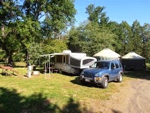
I then connected back onto I-25 heading into Albuquerque and continued back to my campground to spend the rest of the day with the twins and make sure the RV did not get too hot -- we spent most of afternoon outdoors with the awning out and enjoyed its shade and mild temps.  Note the snow among the trees in the picture above -- I thought it would be cooler up there but, was suprised to see so mjuch snow in the shadows of the trees.

Saturday, April 27, 2013

Chaco Canyon - More Input

For those that might consider taking that bumpy section of road (13 miles on CR7950), hopefully you might have more time available for some additional hikes -- like the top of the North Mesa where the view of Pueblo Bonito, Pueblo del Arroyo and Chetro Ketl below would add the best perspective of all that our Native Americans built below.  This wouldn't begin to touch on the other 150 houses or sites elsewhere along the 400 miles of roads they built but, it sure would be worth the climb/hike.
The hike into and around Pueblo Bonito (Spanish for "Beautiful Town") is .73 miles roundtrip and requires climbing stairs and short rises and ducking/stooping through narrow doorways along the route.  Helps you get a feeling of what it must have been like for the indians living there or visiting there -- minus the roofs, ladders and doorways through the roofs, of course.
 
The trail map gives you as good an overall view as possible from ground level and some pictures (like the one to the right) only give a bit of a false impression as the large stones and rubble in the foreground are parts of the north cliff collapse that fell in 1941 after some unusually heavy rains (January 22nd, I believe).  I wondered if there were many Petroglyphs too that might have disappeared from sight when that happened.
Pueblos del Arroyo ("Village by the wash") has a 1/4 mile, roundtrip trail that agains winds about the "D-shaped" great house with climbs, up, down and mostly around the ruins.  I believe this house had 4 or 5 stories at the back near the cliff and stepped down to one level nearest the wash.  Apparently the wash had only been some 18 inches deep and 8 feet across in the late 1800s but, it now is some 30 to 40 feet deep and 100 feet wide due to over-grazing during the last 100 years which allowed more erosion and flash floods.
Many of the rooms along the south side or lowest level had entry through the roofs and they contained fire pits and grinding slabs -- typical of domestic dwellings -- which are not in the older public buildings like Pueblo Bonito.  All this according to the brochure and noted that the construction has been dated from 1025 to 1125.
Chetro Ketl does not have a known meaning to the name but, two Navajo names  for "covered hole", referring to several sealed cavities in the cliff behind and "house in the corner" since it is near a box canyon (or Rincon).  The trail is only 1/2 mile, roundtrip but, a little steep in some places nearest the cliffs behind.


Friday, April 26, 2013

Chaco Canyon -- Amazing Place


After some 3 hours of driving from the campground here outside Albuquerque -- including some 16 miles of wash board dirt roads which had us much of the time not getting above 10 mph -- we reached the paved roads in the park and the modern facilities of the campground were the second stop (after the entrance sign above).

After using the restrooms we (Marilyn and I) headed for the first pullout at Fajada Butte Overlook where we stopped to take in the view and read the signage there.

Our next stop was the Visitor Center to find out more than we gleaned from the brochure I had obtained at the Petroglyph Visitor Center about a week ago.  As expected, the person at the Visitor Center recommended seeing Pueblo Bonito  for sure and even mentioned there would be a guided tour at 2:00 p.m.  The first hike we decided to do was to the Petroglyphs near the Visitor Center and we did that right after getting a quick bite to eat from our backpacks and small cooler -- water bottles filled too. 
After that short hike and the short climb to the canyon face where the Petroblyphs were, we headed on the oneway road to Pueblo Bonito and parked the Jeep.  We hiked and climbed around Pueblo Bonito and Marilyn read all the highlighted copy for each of the numbered stops along the trail.  Simply Amazing that all this was built 1000 to 1300 years ago.  From there a short trail led to Chetro Ketl -- which the person at the visitor center also told us about.  First we had a picnic lunch at the one picnic table near the parking area -- fed the little birds and numerous litte chipmunk-like squirrels that came from all around when we arrived at the table.
 
The Chacoans were master masons and the hundreds of years of construction on all these structures is mind boggling.  The detail and planning for these 4 and 5 story great houses with nearly 600 rooms would seemingly have called for one great master plan but, there were no blueprints left behind.  Only best guesses have been offered by archaelogists and other experts in the field.  It must have been magnicent to see all these structures when they were occupied by all of the thousands of people -- our talented and hard working Native Americans.
 
What a dream and what a vision they had way back then and the hundreds of miles of roads they built too for all the people who came from as far away as Mexico (most likely farther too).  As we visited site after site and saw more great houses and great kivas, it was inspiring and hard to imagine all of them somehow connected together at one time.

I took over 120 picures as we walked around and through some of the structures and these few don't even begin to show all that we saw.  The details and the great kivas where they worshipped were all so varied and so different in their construction -- some with columns, some with pilasters, some with benches and pits.  Truly amazing and worth the bumpy ride on that dirt road leading in (CR7950).


After touring Chetro Ketl and seeing some Navajo masons doing repairs or restoration, we headed to the farthest parking area near Pueblo del Arroyo (Spanish for "village by the wash") where again we hiked through and around this great house -- thought to be home to at least a few Indian tribes such as the Hopi, Pueblo and Navajo as they made their way on their migration paths.  Before we made our way back along that wash board road and to our campground, we made another stop and did a short hike around the lower sections of the Casa Rinconada Community at the base of the South Mesa of the canyon.  The Greatest Kiva there was one of the most impressive we had seen. 
 
Since the winds were picking up and the threat of rain looked imminent we decided not to do the 3.6 mile hike up to the top of the South Mesa and Tslin Kletsin.  The Chacoan Stairway that we saw as we started the trip back may have been an indication of the challenge we might have faced on the trail up the South Mesa (or down) so we may not have been ready for that hike anyway -- though the view from the top of the mesa would probably have been spectacular and awe inspiring.  Maybe another time.

Tuesday, April 23, 2013

Still Waiting to Head North

Little by little, things are improving farther north and I am still getting little things done on the RV as I wait here in Albuquerque.  Found those misplaced festoon lights and replaced the three aisle lights for better night time maneuvering and help in avoiding kicking things with my bare feet -- still get the occasional sticker brought in from walking around the campground -- too hard to see those nasty little things without getting down on my hands and knees.

Ordered a new control panel yesterday for the hydraulic leveling system and it's due in this Friday. Of course, the old one decided to work again today around midday so, I will have a backup either way.  I also got under the RV this afternoon and replaced the tail pipe hanger and u-bolt so, now I don't have to worry about it falling off when I head for Colorado or elsewhere after the summer.  Also, I think I have found every circuit breaker panel and nearly every fuse box inside and outside of this RV and may have to get some backup fuses of various amps in case something happens to blow one of them (no time soon hopefully).

Still haven't gotten to the Sandia Peak Tramway since I spent Monday getting that part ordered and the tramway was only open from 5 p.m. to 8 p.m. today -- too windy and dusty to consider going there today. Thursday, I plan to head for Chaco Canyon and that neighbor (Marilyn) has agreed to join me.  It will be nice to have company for the 3 or more hour drive and someone to take in the sights with too.


I can see the moon out there in the sky above tonight but, the wind is still blowing and visibility along the horizon is pretty poor due to the dust -- most of the clouds have cleared (I think) and it's supposed to get down near freezing tonight so I will monitor the outside temp and crank up the space heaters as needed.

Sunday, April 21, 2013

Old Town Albuquerque

If only I could remember over 50 years ago and the only other visit I have made to this city -- guess I had been distracted by that beautiful, intelligent and firey Indian girl I had met then (so blinded that I didn't even notice or recall the mountains that rise up on the east side of this city).  Too bad snail mail had been the only communications we had developed at that time (other than the telephone, of course) -- long distance to the east coast seemed insurmountable at those times to me.  What could have happened if we had the internet then is only left to my imagination and is now just regrettable.

As I walked around the historic section of the city, I had hoped there might be something to trigger some memory of having been there before but, no such memory came to the surface.  I arrived there by 9:30 this morning and quickly found a space on the plaza there in front of the historic church of San Felipe. How disappointing it was to walk around this beautiful historic section of Albuquerque and not have one single memory of having been there before -- only memories of having played numerous games of chess with Alicia, games of hoops with her younger brothers, a drive-in movie with her and all the siblings, and the horrible night when my younger sister Kathy stepped on the hot grating over the furnace in the living room floor and burned her poor little feet.  Oh yeah! And Alicia breaking her toe when she kicked me so hard for beating her yet again at chess -- she played against the professors at UNM where she attended (and usually beat them).  Guessing now that she only let me win (most likely explanation it seems).

Guess I should have gone into that beautiful church and prayed for something -- anything.  Maybe a new brain or some better connections in the current one.  Those eighteen concrete steps I fell down when I was a kid must have done more damage than just adding a couple more cracks in my skull.

Well, the highlight of my visit to Old Town was meeting a woman in her art gallery who just happened to have been born in Washington D.C. too and even had lived in Alexandria just east of Springfield Mall off Franconia Road.  Not far from where I have my townhouse.  Enjoyed talking with her for a short time before starting the rest of my time roaming about and taking pictures (way more than shown above).

Looking Through the Haze

I should say "dust" as the winds were up again yesterday afternoon and the mountains in the distance disappeared completely from view because of the dust and dirt blowing around.  So glad I had gotten out earlier in the day and took advantage of the reduced wind conditions and abundant sunshine.

This morning I can again see the mountains south of Albuquerque and a piece of the southern peaks where the sun rose around 6:30.
Thought I should put up a few more pics of the more interesting petroglyphs that I had seen (besides the ones already posted).  Will try to get down to the historic district of the city after getting some breakfast -- again before the winds and dust start to kick up.

It would be nice to know what some of the symbols meant and whether some of these are just graffiti added by some idiots.


Saturday, April 20, 2013

Update - Saturday's Hikes

Although I originally thought of heading first down to the nearest canyon to look for more Petroglyphs, as I neared the exit from the campground, I could see the Volcanoes to the north on the other side of I-40 and so I decided to head there first -- in case the winds should return and hit from the west or northwest as predicted.  I could be off the plateau and possibly in the canyon below them later in the morning.

I arrived at the access road to the Volcanoes at about 8:30 so the gate to the parking lot would not open for another half hour so, I hoofed it up the road and took off toward Vulcan Volcano -- the more dominant looking of the three.  After a good half hour of hiking through the sage brush covered landscape, I finally met a couple other hikers with their dog and they confirmed that Vulcan was the most impressive and their favorite of the three.  They pointed me toward the path to the top as they went in another direction.

A beautiful view from the top and all around -- could see the top of the canyon where I would be heading next.  First hike was about an hour and maybe a mile and a half.

Next, I drove to the parking area for Rinconada Canyon and only found a few cars parked there -- restrooms too.  I filled my small bottle with more water and headed out for the 2.5 mile roundtrip hoping to see many more Petroglyphs than the day before.  No disappointment there for sure and the weather was again superb for the hike out and the small climbs I did to get closer to some of the carved images.

I must have taken more than 50 pictures of the numerous petroglyphs that were all along the trail -- some higher up the basalt covered ridges of the canyon.  All worth the climb and the closer looks.  Of course, there were numerous other carvings with dates and names so, forget those.

This afternoon, the skies filled with more clouds and the winds have progressively gotten stiffer and are rocking the RV.  Tiger wants out again to catch the rest of a lizard he caught by the tail -- it broke off, of course and wriggled on the ground for a few minutes after.

Think I hiked 4 or 4.5 miles in all thoroughly enjoyed being out for the great views and exercise.  Tomorrow seems like a good day for checking out the historic section of Albuquerque.


Red Sky Morning - Sailor Nixes Warning

The old saying may be true but, I'm not believing it for today.  There are clouds coming in from the west but, it is mostly clear and the temp at sunrise was 45 and that's over 10 degrees warmer than yesterday -- big question will be the winds and since they are supposed to be out of the west or northwest, I hope they will be less than expected and perhaps just blowing overhead when I get to another trailhead in Petroglyph National Monument.

This time, I have my eyes on the Rinconada Canyon trail that is some 2.5 miles roundtrip and is supposed to have over 300 petroglyphs on the basalt rocks along the canyon rim.  This area had been just slightly visible to my weak eyes from the top of one of the volcanoes yesterday afternoon -- maybe in one of the pictures I had taken.

Tomorrow may be the Sandia Peak Tramway or a visit to the historic section of Albuquerque -- most likely a visit to the city since it is a weekend.  Now for some breakfast and fill that water bottle and hope there is a parking space.

Friday, April 19, 2013

The Volcanoes

Trail to JA Volcano
The trail map has the incorrect name of the road to the trailhead and I can only say it is exit 149A (that is Atrisco Vista Blvd.) -- will check and correct the name tomorrow morning or later today.  As mentioned the Volcanoes Access Rd. is only some 3 or 4 miles north of the interstate and easy to see as you approach with the three volcanoes quite visible on the high plateau to the right.

When I arrived there at the entrance to the road, I saw a couple school buses already up in the parking area and lots of small kids running around -- most vehicle parking was full and there were a number of cars parked all the way down by the road.  I drove in anyway and found a couple spaces open and took one as another two more buses came in behind me with numerous other cars swarming the parking area.  This old man needed to use the restroom so, I hussled there first and then headed up the trail to JA Volcanoe first.


Top of JA Volcano
After climbing JA Volcanoe and taking pictures of the valley in the distance and Sandia Peak beyond, I faced toward the other two volcanoes and could only see the closest one -- Black Volcano.  Vulcan Volcano was obsured by the other volcano so, I decided that I must make it to a point on the other side to see the last of the three volcanoes.

Plenty of time to still make that 1:00 p.m. time I had in mind for the $5 buffet at the casino.  No water with me but, I would get that soon enough when I got back to the Jeep -- and stay ahead of the swarms of youngsters starting to populate the trails behind me.

Vulcan Volcano
Will have to return to this nearby set of volcanoes and make the hike to Vulcan's top.  Maybe some better pictures of some distant peaks to the northeast which seemed to have snow on them -- perhaps the Sangre De Cristo Mountains near Santa Fe.

Did enjoy that buffet afterwards and a good tall iced tea too -- now if only a beautiful woman in a hot red dress had been sitting across from me, that would have really made it even more enjoyable (like at Binkley's in Cave Creek, AZ that special July 4th weekend a few years back).  Let's see $300 for that dinner and $5 for this one -- HMMM.  That expensive one was more memorable for sure.  Oh well, I'm full and that's enough for now.

Searching for Petroglyphs

Seemingly, the perfect day for heading out this morning to nearby Petroglyph National Monument -- winds had finally died down and were predicted to be only 10 mph or less for most of the day.  I figured that the morning sunlight should illuminate the black volcanic rocks and make it easier to see any of the Petroglyphs I might happen upon (even if it was a bit chillier than other days -- only 31 degrees at daybreak).  Most of the canyon walls face to the east too and toward the rising sun.

After a hardy two egg breakfast sandwith, OJ and half of a banana, I headed to the exit (#154A) just 5 miles east on I-40.  The Visitor Center was only 4 or 5 miles north on Unser and there I picked up more than a half dozen trail maps from the helpful Park Service Ranger at the desk -- even one brochure for Chaco Canyon (at the top of my list to see).

Since I had my sights on that $5 buffet for the early afternoon, I decided to head for the trail farthest to the north in Piedras Marcadas Canyon where the half mile trail should take me to five notable Petroglyphs  (ones pictured in the brochure).  The drive there was only some 5.25 miles or so and the little parking lot at the head of the trail seemed to be at the back of shopping center and next to a nice hillside community of pretty homes.

The trail was mostly sand and easy to moderate in difficulty -- just right for this old man and my one bottle of water.  The day had really been perfect weatherwise and I only wish I could have found all five of the ones in the brochure but, it seems I spotted more than they had indicated -- probably too many for them to put in the brochure (some may be pranksters work too).

Nonetheless, I saw lots of what looked like real Petroglyphs and headed back down the trail to my Jeep and decided I should go to another set of trails out near my RV campground -- the Volcanoes.  Only about 3 or 4 miles north on the road I exit of I-40 for my campground.

Thursday, April 18, 2013

1 Dead Cell equals 1 New Battery

Since I am here for a month in Albuquerque, I have been in no rush to do much of anything and thus, I have tinkered with the battery in the Jeep during the past week as I have done other little tasks in the RV -- charging the battery a few times and getting around to the Walmart, Albertsons, Bank of America and the liquor store.  Also, the winds have persisted over the past few days making it less than desirable to be out in the middle of nowhere with the dust and tumbleweeds blowing around.

Finally, after trying to charge the battery more than a few times (with and without the cables attached) and still only being just able to crank/start the Jeep when necessary, I decided to head for the nearest Interstate Battery store to get their opinion on the battery (must be over 3 years old anyway).  As I watched the mechanic check each of the cells specific gravity, I half hoped he would see one bad cell while in the back of my mind I feared there might be some other electrical problem such as the starter solenoid or the starter itself (though it had been replaced just 2 years ago in Tempe along with the AC compressor).  The mechanic checked the first five and they were fine but, the last one visually showed it was bad -- thank goodness.  I didn't have to head for the Jeep dealer across town and the cost of the new battery was worth the peace of mind.


So nice to hear the smooth crank and quick start of the engine now.  For sure, I am ready for that wonderful $5 buffet at the route 66 casino tomorrow and then some of the local sights.

I did get back to the neighborhood near the Walmart to get a picture or two of those homes with the semi-circular rooms like the house on Quitman street in Denver -- my childhood home.

These homes were visible on the top of a steep hillside as I came back from the battery store on I-40W crossing over the Rio Grande river.  There was a wonderful looking pedestrian/bikers bridge running right next to the interstate too.  The neighborhood has lots of gated homes and many of the streets are dead ends just short of the steep drop-off -- with beautiful views of the river below and the peaks just a little east (part of Cibola National Forest).  Perhaps Sandia Heights.